

What the Shoal Remembers
Watershed, Settlement, and the Long Attention of Lawson's Fork

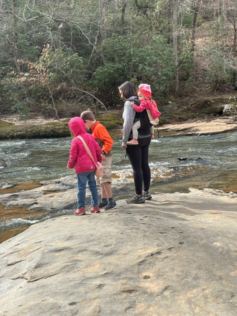
My kids usually hear it before I do (being a 47-year-old who spent too much time in my youth listening to Nirvana, Pearl Jam, and Alice in Chains at decibel levels that weren’t healthy). We will be maybe a quarter mile into the Cottonwood Trail at the Griffin Nature Preserve here in Spartanburg, still in the tunnel of hardwoods where the path bends east along the creek bank, and one of them will stop… Ben, usually, or Lily, and tilt their head in that particular way that means something has arrived in their perception that hasn’t registered in mine just yet. Do you hear that? And then I do. The shoal, working itself over the granite somewhere ahead, white noise resolving as we walk closer into something more particular and more textured. The deeper churn where the water drops and the lighter chatter along the margins, maybe a kingfisher somewhere in the sycamores doing its rattling complaint. The creek announces itself. We have come to listen, even when we think we have only come to walk.
I have been thinking about Lawson’s Fork Creek for a long time now, but it took hiking it with my children to understand what it was actually asking of me as well. It is not a dramatic waterway. It does not carry the mythological weight of the French Broad or the sheer volume of the Broad River into which it eventually drains. It is twenty-nine miles of Piedmont creek winding through Spartanburg County, beginning in the foothills near Campobello and emptying into the Pacolet south of Glendale, modest by almost any measure. But it is, in the particular sense I am working to develop in my ecological writing, a deeply intentional place. A place where the land and the human have been reaching toward each other across an extraordinary span of time, each shaping the other’s form of awareness. My children, stopping on the trail to point at a turtle working its way along the bottom, are participants in something far older than they know. So am I.
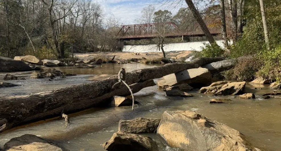
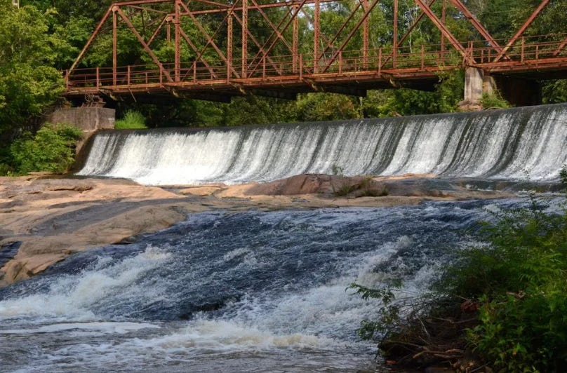
The Piedmont substrate under this watershed began forming something like three hundred million years ago, the residue of a mountain-building event that has long since spent itself, leaving behind a rolling red clay upland cut by rivers still tracing the fault lines and fractures of that ancient geology. The shoals along Lawson’s Fork and the falls at Glendale, with exposed granite shelves that break the current at intervals along the Griffin Preserve, are where resistant rock refused to erode at the same rate as the softer stone around it. They are geologically stubborn places. And because they are stubborn, because they force the water into visibility, audibility, and turbulence, they have drawn human attention for a very long time.
The Cherokee used this landscape primarily as hunting territory, a buffer between their towns to the west and the Catawba to the east. The conventional historical account tends to emphasize the political dimension of that arrangement, and it was, in some sense, political. But there is an ecological dimension that deserves more weight. The Cherokee managed these Piedmont forests through deliberate burning, maintaining open patches of young growth, which historians call old fields, that functioned as wildlife corridors and habitat edges. The landscape that European settlers encountered along the Tyger, Enoree, and Pacolet Rivers was not wilderness in the romantic sense, not untouched nature awaiting human meaning. It was a tended commons, shaped by centuries of purposeful ecological attention. The shoals were practical features of that attentiveness. They were places to ford, to fish, to read the river’s offer. The Cherokee hunted deer and turkey in the fire-managed edges between forest and old field, and the rivers were the readable lines of the whole system, the grammar of a landscape that had been patiently cultivated.

The first Europeans near Lawson’s Fork were Spanish. In 1567, a party under Captain Juan Pardo passed through this part of the Piedmont, and a stone bearing that date was plowed up by a farmer near Inman in 1934, amazingly enough… one of the stranger objects in the Spartanburg Museum’s collection being a sixteenth-century trail marker turned up by a twentieth-century moldboard. Then, after Charleston’s founding in 1670, the region remained outside the boundary of permissible British settlement for nearly another century. The 1755 treaty with the Cherokee opened land grants, while a military defeat of 1761 made colonizers feel more secure. The Scots-Irish who came down from Pennsylvania in increasing numbers after that settled, almost instinctively, along the river bottomlands. They followed the same watercourses the Cherokee had read for generations. They built their first corn mills at the shoals and falls, reading the same energy the creek had always offered.
What the watershed permitted… that phrase keeps returning to me. The Wofford Iron Works at Glendale, one of the earliest industrial operations in the Carolina interior, depended on Lawson’s Fork for its power. The iron went into weapons for the Revolutionary War. The cotton mills that followed a generation later, the Bivingsville Factory established by Dr. James Bivings in the 1830s, later acquired by D.E. Converse and renamed Glendale, were sited at the shoals because the shoals made the wheel turn. Every stage of Spartanburg’s economic development during the transition into the colonizing period, from subsistence farming through iron-working through the textile industry that defined the county’s character well into the twentieth century, was organized around what the watershed would give. The Scots-Irish did not impose their settlement pattern on a passive landscape. They read what the creek was offering and responded, sometimes sustainably, often extractively, always consequentially.
It matters that the mills are gone now, and that the creek is still here.
This is the historical pattern that a framework of ecological intentionality asks us to approach differently. The conventional environmental history of a place like Spartanburg focuses on what human settlement did to the watershed… the mill dams, the textile effluent, the gradual urbanization pressing in from the I-26 and I-85 corridor, the impoundment of the South Pacolet at Lake Bowen for the city’s drinking supply. These are real and significant. But they can leave us with a narrative of pure loss, the land as patient victim and the human as inexorable agent of harm. What I find more generative, and more honest, is to ask not only what we did to the watershed but what the watershed has been doing to us and how it has insisted on its own form of attention across every generation of human presence here.
Merleau-Ponty argues that the embodied subject does not encounter the world as a neutral backdrop against which experience occurs. The flesh of the world co-constitutes the flesh of experience. Perception is not a unilateral act; it is a conversation between a body and an environment that, in some meaningful sense, is already reaching back. Applied to a watershed, to Lawson’s Fork specifically, winding east through the Piedmont toward the Broad and eventually to the Santee and the Atlantic, this suggests that the patterns of human settlement here are not simply human decisions projected onto a passive landscape. They are moments in a longer conversation. The shoal elicited the mill. The mill organized the village. The village carried the shoal’s energy into forms of human community, some of them beautiful, many of them unjust, all of them downstream from the granite outcrop that refused to erode.
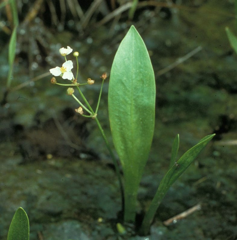
The endangered species along this corridor offer one way to understand what that conversation has cost and what remains. The Bunched Arrowhead (Sagittaria fasciculata), a small federally listed aquatic herb found in the South Carolina Piedmont and Western North Carolina seepage forests of the upper watershed, is among the rarest plants in North America, surviving in only a handful of isolated pockets in Greenville and Henderson Counties. These are places where slow groundwater still seeps undisturbed through clay-underlain slopes beneath a deciduous canopy. Its presence marks the places where the watershed has not been interrupted. The bog turtle and the Carolina heelsplitter mussel, both imperiled species in the Lawson’s Fork–Pacolet system, have similarly narrow tolerances. They are not merely ecological indicators in the technical sense. They are witnesses to a form of continuity and a long patience in the land that has outlasted iron works and cotton gins and mill villages and is now, precariously, outlasting the sprawl that is pressing against the edges of the watersheds from every direction.
The Spartanburg Area Conservancy’s work along Lawson’s Fork is important because it is trying to hold those conditions of continuity open, not just the trail miles and the biodiversity inventories (though those matter for a number of reasons) but the particular quality of attention the creek itself sustains. The 110-acre Griffin Preserve exists because enough people understood, at some level, that this stretch of Lawson’s Fork was doing something irreplaceable. The cottonwoods along the bank, the sycamores in the floodplain, the exposed granite shelves where the water breaks white and loud… these are not amenities added to the creek. They are the creek’s way of making itself available to perception.
We stopped last fall at the shoal where the Cottonwood Trail comes closest to the water, and Emmylou crouched down at the bank the way children do, with her whole body, as though attention required getting as low as possible. There was a turtle on a half-submerged log, far enough out that you had to hold still to see it clearly. She held still. I watched her watching it, and I thought about the Cherokee hunters standing in this same valley reading the burned-over edges for deer, and the mill workers who heard this same water every morning of their working lives from the village up on the bank, and the botanist who first documented the Bunched Arrowhead in a seepage forest a few miles upstream, kneeling in the saturated soil to record something the land had been quietly maintaining for centuries without any record at all.
The shoal does not remember these things in any way that is directly available to us. But it continues to do what it has always done and break the water’s surface into sound and light, elicit a particular quality of attention from whatever body comes within earshot, and offer, to anyone who stops long enough, the experience of being called into awareness by something that was here before you and will be here after. My children hear it before I do. The invitation the watershed extends is not complicated. It only requires that you be present enough to notice when the creek begins to announce itself through the trees, and that you stop, and that you listen to what the water is doing over the stone.
That is where I want to start… not with the crisis, not with the loss, though both are real, but with the shoal, and with the attention it asks of us, and with the long, patient history of what happens when people actually give it.
Further Reading & Resources
Local & Regional History
Landrum, J.B.O. History of Spartanburg County. Franklin Printing, 1900. Digitized at the Library of Congress: loc.gov/item/01031332 The foundational county history, available free online.
Kovacik, Charles F., and John J. Winberry. South Carolina: The Making of a Landscape. University of South Carolina Press, 1989. The standard geographic and ecological history of the state; essential background on Piedmont settlement and river systems.
South Carolina Encyclopedia: “Spartanburg County,” “Piedmont,” “Pacolet River” are good keywords here: scencyclopedia.org. Rigorously sourced, freely accessible reference on the history and ecology of the region.
Spartanburg County Historical Association spartanburghistory.org Maintains Walnut Grove Plantation, the Price House, and the Regional History Museum… good starting point for deeper county history research.
Kennedy Room of Local and South Carolina History, Spartanburg County Public Libraries spartanburglibraries.org Our primary archive for Spartanburg County history, including maps, manuscripts, and newspaper records.
Watershed & Ecology
Palmetto Conservation Foundation: Lawson’s Fork Creek & Pacolet River Blueway: gopaddlesc.com Over 50 miles of mapped river travel through the watershed, with notes on ecology and historic mill sites.
South Carolina Native Plant Society “Bunched Arrowhead, Our Rarest Plant”: scnps.org On the endangered Sagittaria fasciculata and the Piedmont seepage forests it depends on.
SC Department of Environmental Services: South Carolina Watershed Atlas: gis.des.sc.gov/watersheds Great interactive mapping of all SC watersheds, including the Broad River basin that drains Spartanburg County.
USGS Water Data for the Nation: Lawson’s Fork Creek at Spartanburg: waterdata.usgs.gov Real-time streamflow data for the creek.
Conservation & Trails
Spartanburg Area Conservancy (SPACE): spartanburgconservation.org Manages the Edwin M. Griffin Nature Preserve (Cottonwood Trail) and Glendale Shoals Preserve
Glendale Outdoor Leadership School: guided trips on Lawson’s Fork Creek and the Pacolet River: glendalesc.com